A Virtual Tour of Pompeii
presented by The Rock Doctor
Click here for
background Pink Floyd
music , in honor of the DVD
release of the 2003 director's cut of Pink Floyd Live at Pompeii
(1972 ).
In the Spring of 2006, I was priviledged to take a personal excursion
to Italy that included my pilgramage to Pompeii, an archeological
excavation of an ancient Roman town laid waste by an eruption of Mount
Vesuvius in 79
A.D. The Pompeii site is much larger than I had ever
imagined, measuring about 0.75 kilometers x 1.25 kilometers,
as this Google Earth link shows:
Google Earth view of Pompeii
If you don't have Google
Earth....GET IT!!! However some
computers and/or web connections are too slow to handle Google Earth,
so at the bottom of the page, I provide the satellite / airphoto views
I'm discussing. The ancient city wall outlines an oval
shaped city. Both the maps below and the images show that
about 1/3 of the site has yet to be unearthed, and there were
archeologists working when I was there! It might be hard to
identify the city among the modern city of Pompeii. It helps if
you:
zoom on the Pompeii Stadium on the
city's eastern end using Google Earth
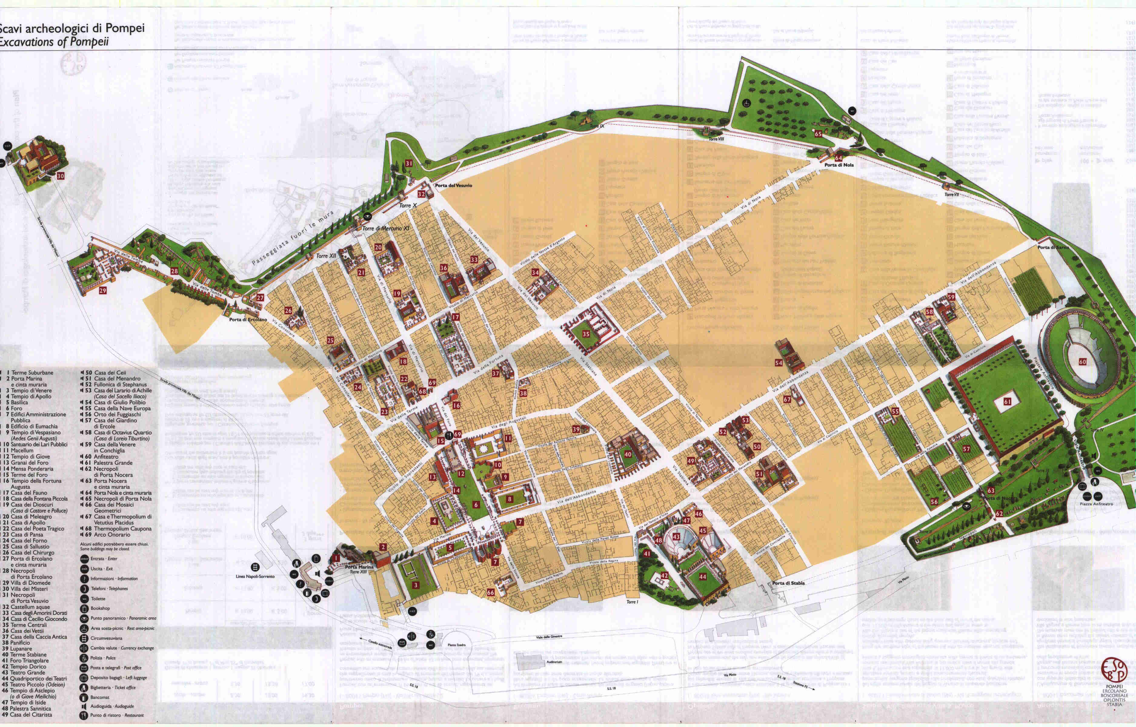
The tourist map of Pompeii at the first resolution below gives you the
overall layout of Pompeii. The same map is then shown at a higher
resolution in order to find the numbered items on the map that
correspond to my photos.
Now, before getting on the ground with the photography, remember this
whole town was buried in volcanic ash by a pyroclastic flow (nuee
ardente) from the Plinian (as described by Pliny the Younger) eruption
of Mt. Vesuvius in 79 AD. Mt. Vesuvius is north-northwest
of the Pompeii. It looms in the background as you look down Via
Stabiana, or from the main town square, or when looking back from the
overlook of the Necropoli in the city's southeast corner.
So...
Here's a Google Earth view of the Mount Vesuivius area,
centered on the Bay of Naples directly south of Mount Vesuvius, and
directly west of Pompeii, with Naples to the northwest, Sorrento (where
Mrs.
Conclusion of Monty
Python fame goes for a fortnight after burying her cat) on a
peninsula to the southwest,
and Pompeii to the south-southeast of Mt. Vesuvius.
My kids love to zoom onto Mt.
Vesuvius' crater. Then again, so do I. The view from the Summit of Mt.
Vesuvius is breathtaking. Once there, your view is to the
north. Use the "rotate right" button on the right side to spin
about the summit counter-clockwise to the northwest where you can see
Naples and the Bay of Naples. Keep spinning and you see the open
Mediterranean Sea to the west. Keep spinning and you see the
mountains behind Sorrento to the southwest. Stop when you reach
the view to the south-southeast. This is the direction the blast
went that buried Pompeii. While facing this way, it's kinda neat
to imagine that you are a piece of volcanic ash, and see how you would
blast to Pompeii by clicking on this
link to Pompeii (same as above) and letting Google Earth fly you
there. Click here to
come back to the summit view facing north (or continue rotating
until facing north). Once facing north again, use Google Earth's
tilt-up button to look down the north slope of Mt. Vesuvius into the
valley with a ridge on the opposite side. The south-facing slope
(facing toward you) of the ridge on the opposite side of the valley is
the wall of a caldera, a fault-bounded, down-dropped basin that is the
remains of a collapsed volcano or magma chamber. The north-facing
slope of the ridge opposite the ridge crest (facing away from you) is
the remaining part of the flank of Mt. Somma, a much larger volcano
that predated the relatively modern Mt. Vesuvius. Mt. Vesuvius is
a stratovolcano that sits in a caldera, the remains of the much larger
Mt. Somma stratovolcano that began collapsing with the Pomici di Base
eruption 18,300 years ago. For details of the geology and eruptive
history of Mt. Somma / Mt. Vesuvius, visit the official website of the Vesuvius
Observatory. While peering into the caldera valley, you
can see the remains of a flow (pyroclastic?, lava?,
lahar?) that ran down the side of Mt. Vesuvius and was then diverted to
the west by the caldera wall. The caldera wall may afford Naples
some degree of protection from future pyroclastic flows coming down the
slopes of Mt. Vesuvius, diverting them to Portici, Herculaneum
(Ercolano), and Torre del Greco down the coast. However, the
whole region is heavily populated.
Click here to
get an aerial view of the diverted flow inside the caldera.
Also notice the road leading to the summit of Mt. Vesuvius. The
road leads to the Vesuvius
Observatory south of the crater rim , this view toward the south
(toward Pompeii). Tilting down a little from the aerial lava flow
view, this view from the
northwest (aerially from Naples) shows the complete caldera structure.
Various profiles of this structure can be found in my Naples to Pompeii
train ride photos.
My Photographs and Movies of Pompeii
First, how about getting there. You probably will find Pompeii's
official site very helpful for directions, as well as information on
the site and its history in general:
www.pompeiisites.org
I landed in Rome on an art history excursion heading north, so I stole
a day and went south to Naples and on to Pompeii. I traveled from
Rome to Naples by Itali I then caught the Naples
metro train system to Pompeii, which runs along the coast from Naples
northwest of Mt. Vesuvius to Pompeii southeast of Mt.
Vesuvius. As a result, you get great profile views of
Mt. Vesuvius as you go.
The Naples to
Pompeii train ride views of Mt. Vesuvius.
The first view out the train window shows the profile as seen from
Naples to the northwest. If you take the last Google Earth view of the
complete caldera structure and flatten it, you see this same
profile in Google Earth. The train went from Naples in the
northwest along the coast west, southwest, and south of Mt.
Vesuvius. Similarily, compare the successive train window views
to these Google Earth views:
Vesuvius profile from west
Vesuvius profile
from southwest (flatten this one with tilt)
Vesuvius profile from
south
Mt. Vesuvius stands alone in the southern profiles, obscuring the
caldera wall of Mt. Somma.
A view from the
southeast shows the caldera wall on the northeast side of the
mountain. This is similar to ...
the profile view of Mt.
Vesuvius from Pompeii
The Pompeii tourist map below is the same as above, but shown at a
higher resolution. These two resolutions will help you navigate
Pompeii and find the numbered items for the remainder of the photos I
have to present:
;lsdjf;askj
kjlhjl